Start Point

Music Pavilion Weidach (P15)

End Point

Music Pavilion Weidach (P15)

Difficulty

Easy

Total Distance

5,00 km

Descent Meters

50 m

Ascent Meters

50 m

Highest Point

1160 m

Total Time

01:30 h

Status

Partially open

Map & Elevation Profile

Start Point

Music Pavilion Weidach (P15)

End Point

Music Pavilion Weidach (P15)

Difficulty

Easy

Total Distance

5,00 km

Descent Meters

50 m

Ascent Meters

50 m

Highest Point

1160 m

Total Time

01:30 h

Status

Partially open

Hiking

Best Time

Partially open

Jan

Feb

Mar

Apr

May

Jun

Jul

Aug

Sep

Oct

Nov

Dec

Hiking tour

Village walks

This circular hike leads through part of the Leutasch Valley and combines moments of water, forest, and pure enjoyment in a leisurely walking tour at the foot of the Wetterstein Mountains.

Our starting point is the music pavilion in Weidach, which you can reach by car (P15) or via the Weidach Zentrum bus stop. Enjoy a short loop around the natural biotope behind the pavilion before following the signpost towards “Weidachsee” at the road junction. Pass the Katzner Chapel and turn left again opposite the main entrance of Hotel Quellenhof. Follow the path until you reach the idyllic shore of Lake Weidachsee.

Lake Weidachsee is a fishing lake where anyone can fish for a small fee – even without a fishing license. Continue past the lake café with its own fishery – a stop here is particularly tempting – and walk left along the lakeside promenade.

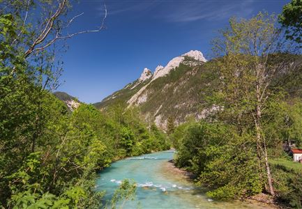
At the southern shore, the trail leads into the forest, where it forms a small loop. At the junction, keep left towards Kirchplatzl. From here, you reach the Leutascher Ache River, which flows through the entire 16-kilometre-long valley and is a scenic companion in every

Similar Tour Suggestions

Schausäge der Triendlsäge

Hiking

Circular walking path to the Inn Triendlsäge

Length

4,80 km

Duration

01:15 h

Uphill

101 hm

Altitude

1215 hm

Difficulty

Easy

Abendstimmung am Seekirchl in Seefeld im Sommer.jpg

Hiking

Circular walk in the Möserer valley

Length

3,10 km

Duration

00:45 h

Uphill

12 hm

Altitude

1196 hm

Difficulty

Easy

Porta Claudia Scharnitz - Tor mit Weg.jpg

Hiking

Circular hiking trail Porta Claudia

Length

2,50 km

Duration

01:00 h

Uphill

125 hm

Downhill

120 hm

Altitude

1085 hm

Difficulty

Easy

Scharnitz - Wanderung Dorfrunde - Kirche in Scharnitz.jpg

Hiking

Scharnitz cultural hiking trail

Length

3,00 km

Duration

01:00 h

Uphill

53 hm

Altitude

1005 hm

Difficulty

Easy

Bienenlehrpfad Reith - Infotafel am Bienenhotel (1).jpg

Hiking

Hike Bee Nature Trail

Length

2,50 km

Duration

01:00 h

Uphill

72 hm

Altitude

1185 hm

Difficulty

Easy

Wildmoosalm im Sommer - Hütte mit Kuh.jpg

Hiking

Hike to the Wildmoosalm alpine hut

Length

5,80 km

Duration

01:45 h

Uphill

131 hm

Altitude

1305 hm

Difficulty

Easy

Blick ueber Wildmoos nach Seefeld.jpg

Hiking

Circular tour around the Brunschkopf

Length

13,10 km

Duration

04:00 h

Uphill

275 hm

Downhill

272 hm

Altitude

1369 hm

Difficulty

Easy

Scharnitz - Wanderung zur Adlerkanzel - Blick auf die Isar.jpg

Hiking

Circular village walk Scharnitz - Gießenbach

Length

6,10 km

Duration

01:30 h

Uphill

42 hm

Altitude

1013 hm

Difficulty

Easy